Bureau of Land Management
Solar Energy Permitting and Program Resources
| Nevada Variance Areas | Millers SEZ |
 |
 |
The Millers Solar Energy Zone (SEZ) is a designated leasing area (DLA) located in Nevada in a semiarid basin with undeveloped scrubland. The SEZ is located on BLM-administered land within the Battle Mountain District.
The Millers SEZ has a total area of 16,787 acres (68 km2). In the 2011 Supplement to the Draft Solar PEIS, 253 acres (1.0 km2) consisting of Ione Wash and a small wetland area in the southern portion of the SEZ were identified as non-development areas, leaving the SEZ with a potentially developable area of 16,534 acres (66.9 km2). No additional changes to the SEZ developable area were made in the 2012 Final Solar PEIS.
The Millers SEZ is located in Esmeralda County in southern Nevada, 44 mi (71 km) east of the California border. The SEZ is located in Big Smoky Valley, lying between Lone Mountain to the south, Monte Cristo Range to the west, and San Antonio Mountains to the east. In 2008, the county population was 664, while adjacent Nye County to the west had a population of 44,175. The nearest town is Tonopah, Nevada, about 15 mi (24 km) to the west.
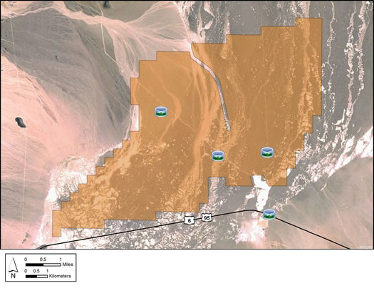
Land within the Millers SEZ is undeveloped scrubland characteristic of a high-elevation, semiarid basin. Vegetation is generally sparse in much of the SEZ, with widely spaced low shrubs and much bare soil, particularly in the playas. The vegetation is predominantly greasewood-shadscale. A number of washes, including Ione Wash, cross the SEZ in a north-south direction.
The Millers SEZ is undeveloped and rural, with few permanent residents in the area. Transmission lines, fences, and roads are present within the SEZ, and there is some evidence of off-highway vehicle use. Part of the SEZ is authorized by the BLM for grazing.
The Millers rest stop and a communications tower are nearby on U.S. 6. Transmission towers and lines are found along U.S. 6 and also between the highway and the SEZ.

The nearest major road access to the SEZ is via U.S. 95/U.S. 6, which runs along its southern border. A 120-kV transmission line passes through the SEZ.
In the 2012 Solar PEIS, the BLM committed to establishing a monitoring and adaptive management strategy for each solar energy zone (SEZ). Through these strategies, the BLM will take an active role in the collection of baseline data for the SEZs.
The BLM has not yet begun the monitoring and adaptive management strategy for the Millers SEZ. However, the BLM has conducted a pilot monitoring and adaptive management strategy for the Riverside East SEZ. In May 2016, the BLM released the Riverside East Solar Energy Zone Long Term Monitoring Strategy Final Report. The monitoring strategy document (PDF, 16.6 MB) is now available.
In the 2012 Solar PEIS, the BLM committed to preparing solar regional mitigation strategies (SRMSs) for the solar energy zones (SEZs). These regional mitigation strategies were intended to simplify and improve the mitigation process for future solar projects in SEZs.
SRMSs have been completed for two Nevada SEZs (Dry Lake and Dry Lake Valley North), but not for the Amargosa Valley, Gold Point, or Millers SEZs in NV. With IM-2019-018, the BLM established policy that compensatory mitigation could not be required as a condition for project approvals. However, with the issuance of IM 2021-038 on July 14, 2021, the BLM rescinded the previous IM-2019-018. The BLM expects to establish policies which are aligned with EO 13990, SO 3398, and the priorities of the Department. During this interim period offices should consider and implement compensatory mitigation on a case-by-case basis, in consultation with state office and national office program specialists and the Office of the Solicitor as needed.