Bureau of Land Management
Solar Energy Permitting and Program Resources
The Approved Record of Decision for Resource Management Plan Amendments for Utility-Scale Solar Energy Development was issued on December 20th, 2024 — details are available on the BLM's Utility-Scale Solar Energy Development PEIS/RMPA webpage. Relevant information on the 2024 Western Solar Plan and the BLM's Renewable Energy Rule issued in July 2024, is in the process of being updated on this website.
| Nevada Variance Areas | Dry Lake SEZ |
 |
 |
The Dry Lake Solar Energy Zone (SEZ) is a designated leasing area (DLA) located in Nevada in Dry Lake Valley in a semiarid basin with undeveloped scrubland. The SEZ is located on BLM-administered land within the Southern Nevada District.
In the 2010 Draft Solar PEIS, the proposed Dry Lake SEZ had a total area of 15,649 acres (63 km2). In the 2011 Supplement to the Draft, the SEZ was reconfigured to include only the southernmost area northwest of I-15, in order to mitigate impacts on various resources, including impacts on desert tortoise and potential impacts on military operations. In addition, 469 acres (1.9 km2) of floodplain and wetland non-development areas within the remaining SEZ boundaries were identified. The remaining developable area within the SEZ is 5,717 acres (23 km2). No additional changes to the SEZ developable area were made in the 2012 Final Solar PEIS.
The Dry Lake SEZ is located in Clark County in southern Nevada, in an undeveloped rural area in Dry Lake Valley, bounded on the west by Arrow Canyon Range and on the southeast by Dry Lake Range. In 2008, the population of Clark County was 1,879,093. The towns of Moapa and Overton are as close as about 23 mi (37 km) northeast and 26 mi (42 km) northeast of the SEZ, respectively.
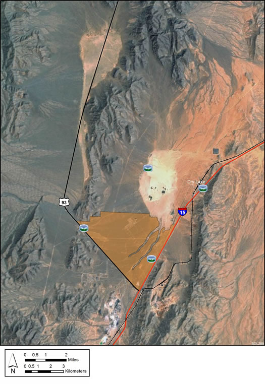
The land within the Dry Lake SEZ is undeveloped scrubland, characteristic of a semiarid basin. Vegetation within the SEZ is predominantly creosotebush and other low shrubs.
Lands within and near the SEZ contain multiple transmission lines and related facilities, several power plants and other industrial facilities, mining operations, I-40, other roads, and a railroad. In addition, there is debris scattered throughout the SEZ.

The nearest major roads accessing the Dry Lake SEZ are I-15, which runs along the southeastern border of the SEZ, and U.S. 93, which runs along the southwest border of the SEZ. Two designated transmission corridors that are heavily developed with numerous natural gas, petroleum product, and electric transmission lines (including a 500-kV transmission line) pass through the SEZ.
On June 30, 2014, the BLM Nevada State Office held a competitive leasing auction for six parcels in the Dry Lake SEZ, selecting three potential developers. The auction was held in accordance with a Notice of Competitive Auction for Solar Energy Development on Public Lands in the State of Nevada published May 30. The BLM offered approximately 3,083 acres of public land in 6 parcels within the SEZ, and used a competitive sealed and oral bid process to select preferred applicants to submit ROW applications and plans of development for solar energy development in the Dry Lake SEZ.
The auction resulted in $5.8 million in aggregate bids for the six Dry Lake SEZ parcels that were offered. This represented a 90-fold premium over the aggregate minimum bid amount. The BLM has summarized the successful bids on a Southern Nevada District Office announcement.
Documents that comprised the Dry Lake SEZ Bid Package are available below.
Note: The BLM hosted a webinar for interested bidders on Tuesday, June 17 to discuss the bidding process and answer any questions regarding the competitive auction scheduled for June 30, 2014 for the Dry Lake SEZ. Notes from this webinar are now available.
During the webinar, a question was asked regarding the solar regional mitigation fee to be charged for projects within the SEZ. The BLM Southern Nevada District Office anticipates that the Dry Lake Mitigation Strategy recommended amount of $1,836 per acre will be the fee for regional offsite mitigation. This per acre mitigation does not include tortoise fees at the current rate of $836 per acre, bonding fees, or fees for other offsite mitigation measures that may be identified during the NEPA review of the Plan of Development for a specific project. The final regional mitigation fee is subject to NEPA review and final decision for a specific project. The BLM is conveying this information on anticipated costs to help potential applicants understand costs related to project development.
For more information regarding the auction contact Greg Helseth, Renewable Energy Project Manager, by telephone at 702-515-5173 or by email at [email protected].
In the 2012 Solar PEIS, the BLM committed to establishing a monitoring and adaptive management strategy for each solar energy zone (SEZ). Through these strategies, the BLM will take an active role in the collection of baseline data for the SEZs.
The BLM has not yet begun the monitoring and adaptive management strategy for the Dry Lake SEZ. However, the BLM has conducted a pilot monitoring and adaptive management strategy for the Riverside East SEZ. In May 2016, the BLM released the Riverside East Solar Energy Zone Long Term Monitoring Strategy Final Report. The monitoring strategy document (PDF, 16.6 MB) is now available.
In the 2012 Solar PEIS, the BLM committed to preparing solar regional mitigation strategies (SRMSs) for the solar energy zones (SEZs). These regional mitigation strategies were intended to simplify and improve the mitigation process for future solar projects in SEZs.
In March 2014, the BLM released the Regional Mitigation Strategy for the Dry Lake Solar Energy Zone (BLM Technical Note 444) (PDF, 3.9 MB), a pilot effort by the BLM that identifies mitigation priorities and options in advance of development. The SRMS takes into account the resource conditions of the land and regional trends informed by BLM's recent Rapid Ecoregional Assessments, and was the first of several such mitigation strategies to be developed for SEZs by the BLM. In December 2015, the Implementation Plan for the Dry Lake Solar Energy Zone Regional Mitigation Strategy (PDF, 569 KB) was released. This document details the selection of the Piute-Eldorado Valley ACEC as the mitigation location to compensate for resources that will be lost as a result of solar development in the Dry Lake SEZ. Both the SRMS and the Implementation Plan were developed in collaboration with stakeholders.
With IM-2019-018, the BLM established policy that compensatory mitigation could not be required as a condition for project approvals. However, with the issuance of IM 2021-038 on July 14, 2021, the BLM rescinded the previous IM-2019-018. The BLM expects to establish policies which are aligned with EO 13990, SO 3398, and the priorities of the Department. During this interim period offices should consider and implement compensatory mitigation on a case-by-case basis, in consultation with state office and national office program specialists and the Office of the Solicitor as needed.
The purpose of the Dry Lake Model is to assess potential impacts associated with groundwater withdrawals to support solar energy development in the vicinity of the Dry Lake SEZ. This SEZ is located in the Garnet Valley (Hydrologic Area 216).
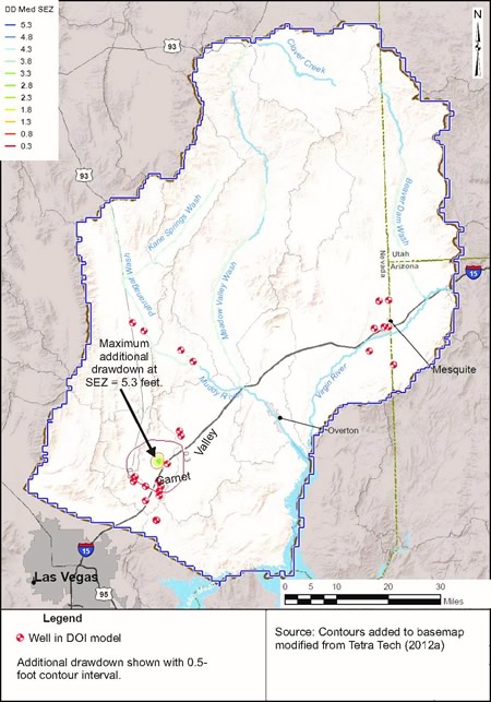
The Dry Lake SEZ model is a modification of a model recently constructed by the Department of Interior (DOI) to assess groundwater impacts in a region including Garnet Valley. The model was created using the U.S. Geological Survey's MODFLOW 2000 code. Pre- and post-processing was performed using Groundwater Modeling System (GMS) version 9. Modeling was performed by selecting a future pumping scenario addressed in the DOI model and imposing additional stress on the system due to assumed future SEZ water requirements. Twenty years of high-, medium-, and low-demand groundwater pumping at the SEZ were modeled, producing estimates of the additional groundwater drawdown due to full build-out of the SEZ.
The Dry Lake SEZ model report has further information regarding its development and results.
The Dry Lake model files are contained in a single .zip file. Please see the “Implementing the custom DOI files for display in GMS.txt” file for instructions for using the DOI model files.
Note: Modeling was performed using GMS version 9.1.4 (64-bit) with a build date of May 1, 2013. The files are packaged in a single zip file. When unzipped, they may be useable by older or newer versions of GMS or by other commercial graphical user interfaces; however, functionality cannot be guaranteed.
Alterations to the Dry Lake Model could be made with the incorporation of new data regarding the hydrogeological framework and aquifer parameter values. As projects are planned, constructed, and begin operations additional groundwater pumping scenarios can be analyzed and new data on head observations in monitoring wells can be used to refine the model.
For questions regarding the Dry Lake Model, please contact John Quinn.