Variance Process Lands
The DRECP Record of Decision (ROD) identified approximately 40,000 acres of variance process lands (VPLs), which are areas where renewable energy development may be considered and could be approved without a plan amendment.
Areas in the DRECP identified as VPLs consist of:
- A subset of the variance lands identified in the 2012 Western Solar Plan. The BLM applied the same screening criteria as the 2012 Solar Programmatic EIS (PEIS) using new, updated and finer scale data. Additional screening criteria specific to the resources in the Land Use Plans were also applied to exclude additional lands to further reduce potential resource conflicts and incorporate new information into decision making. This process reduced the number of acres of variance lands in comparison with those identified in the 2012 Western Solar Plan. A list of the 2012 Solar PEIS screening criteria that had new, updated or finer scale data employed and the additional Land Use Plan specific screening criteria is listed below and appears in Table 14 of the DRECP ROD.
- Additional lands that, based on current information, have moderate to low ecological value and ambiguous value for renewable energy.
VPLs are open for solar energy applications; however, all solar energy development applications have to follow a variance process before the BLM would determine whether to continue with processing them. The permitting requirements specific to VPLs provide additional information.
During its NEPA analysis for future renewable energy development in VPLs, the BLM will tier to this analysis, as appropriate, in order to streamline the project -level review. Under NEPA, “tiering” refers to the coverage of general matters in broader environmental impact statements with subsequent narrower environmental analysis, incorporating by reference the general discussions and concentrating solely on the issues specific to the analysis subsequently prepared (40 CFR 1508.1(ff)). When processing future land use authorizations for renewable energy that differ from the technologies analyzed, the BLM will evaluate the adequacy of the existing analysis, and may require analysis beyond that necessary for tiering to the programmatic document.
Screening Criteria Used to Identify VPLs
- DFAs – applications in DFAs will not be subject to the variance process.
- Interagency biological reserve envelope
- Lands included in new and expanded ACECs and National Conservation Lands.
- All designated and proposed critical habitat areas for species protected under the Endangered Species Act of 1973 (as amended).
- All areas with BLM inventoried wilderness characteristics.
- Developed recreational facilities, special-use permit recreation sites, all designated OHV-open areas, all SRMAs, and all Long-Term Visitor Areas identified in the DRECP LUPA.
- All areas where the BLM has made a commitment to state agency partners and other entities to manage sensitive species habitat.
- All Desert Tortoise translocation sites identified in applicable land use plans, project-level mitigation plans or ESA Section 7 Biological Opinions.
- All wildlife migratory and movement corridors identified in applicable land use plans.
- All Big Game Winter Ranges identified in applicable land use plans, such as mule deer area in the Bishop RMP.
- Lands Classified as Visual Resource Management (VRM) Class I or II in the applicable action alternatives.
- National Historic and Natural Landmarks identified in applicable land use plans and identified in the applicable action alternatives.
- Lands within the boundaries of properties listed in the National Register of Historic Places.
- Designated Wild and Scenic River segments, and river segments determined to be eligible or suitable for Wild and Scenic River status identified in applicable land use plans, including any associated protective corridors identified in the Wild and Scenic River designation or proposal.
- Lands within a solar, wind or geothermal energy development application area found to be inappropriate for energy development through an environmental review process and ROD/CDCA Plan Amendment.
- All lands within the Mojave Trails National Monument and Sand to Snow National Monument and all conservation lands acquired outside of the Monuments through donations or use of Land and Water Conservation Funds.
- Variance land parcels smaller than 280 acres and/or not capable of being combined with other BLM variance parcels or non-BLM lands in DFAs to reach the 280-acre minimum size.1
- Narrow stringers on spur roads between existing or proposed areas conserved or specially managed.
- The area around ancient pluvial lake basins that contain Late-Pleistocene and Holocene shorelines, the exclusion areas to be determined based on the hydrologic history of the particular pluvial lake and to include a 500-meter buffer extending out from the highest strandline dating to the time of human occupation.
- Known archaeological sites.
- Areas within the viewshed of National Historic Sites.
- Areas within five miles of the centerline of National Scenic and Historic Trail Corridors. All microphyll woodlands.
- Lands within 0.25 miles of any surface water source or riparian areas (seeps, springs, lakes, ponds, streams, perennial rivers, and streams).
- Wild Horse or Burro Herd Management Areas.
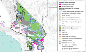
 Full Resource Map