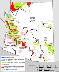
Renewable Energy Development Areas
The 2013 Restoration Design Energy Project (RDEP) Record of Decision (ROD) identified 192,100 acres of Renewable Energy Development Area (REDA) lands in Arizona (defined as designated leasing areas (DLAs) in the 2017 updates to right-of-way (ROW) regulations), areas where solar and wind energy development is likely to be compatible with resource objectives.
All of the REDAs are located within variance areas identified in the 2012 Western Solar Plan, and are
- near transmission lines or designated corridors;
- close to population centers or industrial areas;
- in areas where impacts on water usage would be moderate; and
- have few known resource impacts or have been previously disturbed, such as retired agriculture properties.
The RDEP ROD also identified criteria for identifying REDAs. These criteria are as follows:
- Areas more likely to have few resource conflicts that may affect development.
- Areas close enough to transmission to make it efficient and cost effective to bring the energy online.
- Areas with potential or existing energy generation near the point of demand, such as cities, towns, or industrial center.
- Areas with additional resource protection measures including:
- Implementing water resource design features, Water Protection Zones.
- Prioritizing the available disposal lands for renewable energy purposes and add criteria to favor disposal in a manner that creates additional social and environmental benefits.
- Areas with Known Sensitive Resources Eliminated from REDA Consideration:
- BLM Areas of Critical Environmental Concerns
- BLM Backcountry Byways
- BLM Designated Wilderness and Wilderness Study Areas
- BLM lands with wilderness characteristics managed to protect those characteristics
- BLM lands with wilderness characteristics not managed to protect those characteristics
- BLM Visual Resource Management Classes I, II, and III
- BLM Special Recreation Management Areas
- BLM ROW exclusion or avoidance areas
- BLM Herd Management Areas
- Gila River Terraces ACEC
- Cultural sites well documented by the BLM, including House Rock Valley, Poston Butte, Petrified Forest Expansion Area, Gila River Terraces , and Clanton Hills
- Designated BLM utility corridors
- National Monuments
- National Conservation Areas
- Wild and Scenic Rivers (either eligible for or suitable for inclusion in the National Wild and Scenic Rivers System or rivers included in the National Wild and Scenic Rivers System)
- National Park System units, including Petrified Forest National Park Expansion Area
- National Park System National Historic Trails (0.25-mile buffer each side)
- Tribal lands
- Military lands
- State parks
- State wildlife areas
- USFWS lands
- The Nature Conservancy conservation easements, Audubon Society land, and private conservation easements
- US Forest Service Designated Wilderness
- US Forest Service Established Research Natural Areas
- US Forest Service Inventoried Roadless Areas
- US Forest Service Heber Wild Horse and Burro Area
- US Forest Service Special Interest Management Areas
- Incorporated cities (except when BLM land is included within the boundaries of an incorporated city)
- AGFD Areas of Conservation Potential, Tiers 4, 5, and 6
- AGFD important big game habitat, including bighorn sheep, black bear, elk, javelina, mountain lion, mule deer, turkey, and white-tailed deer.
- Special status species, including threatened, endangered, and BLM sensitive species locations
- AGFD wildlife corridors
- USFWS critical habitat for threatened and endangered species
- BLM sensitive species habitat
- Sonoran desert tortoise (Gopherus agassizii) Sonoran population habitat categories I, II, and III
- Desert tortoise conservation areas from the 2012 Solar PEIS
- National Wetland Inventory wetlands
- Water bodies (lakes, rivers, and dry lakes)
- Federal Emergency Management Agency 100-year floodplains
- Areas of high potential for known mineral deposits, metallic mineral districts, and Holbrook Basin potash potential
- Sensitive fossil resources
- Severe soils: Clay Springs (runoff medium to rapid and erosion hazard moderate to severe) and Rositas (wind erosion severe if natural surface and cover disturbed)
- Greater than 5 percent slopes (or greater than 15 percent slopes for areas with wind potential)
 Full Resource Map