Bureau of Land Management
Solar Energy Permitting and Program Resources
The Approved Record of Decision for Resource Management Plan Amendments for Utility-Scale Solar Energy Development was issued on December 20th, 2024 — details are available on the BLM's Utility-Scale Solar Energy Development PEIS/RMPA webpage. Relevant information on the 2024 Western Solar Plan and the BLM's Renewable Energy Rule issued in July 2024, is in the process of being updated on this website.
| Arizona Variance Areas | Brenda SEZ |
 |
 |
The Brenda Solar Energy Zone (SEZ) is a designated leasing area (DLA) located in Arizona in a semiarid basin with undeveloped scrubland. The SEZ is located on BLM-administered land within the Lake Havasu Field Office.
The Brenda SEZ as proposed in the 2010 Draft Solar PEIS had a total area of 3,878 acres (15.7 km2). In the 2011 Supplement to the Draft Solar PEIS, 31 acres (0.13 km2) of the Bouse Wash in the northeastern portion of the SEZ were identified as a non-development area, leaving the SEZ with a potentially developable area of 3,865 acres (15.6 km2). In the 2012 Final Solar PEIS, the boundaries of the proposed Brenda SEZ were reduced, eliminating the area of Bouse Wash on the east side of the SEZ and eliminating the area on the west side of the SEZ to the west of the county road (a total of 530 acres [2.1 km2]. The final potentially developable area of the SEZ as identified in the 2012 Western Solar Plan is 3,348 acres [13.5 km2])
The Brenda SEZ is located in La Paz County in west-central Arizona, 32 mi (52 km) east of the California border. The SEZ is located on Ranegras Plain, bounded on the north by Bouse Hills, on the west-southwest by Plomosa Mountains and Bear Hills, and on the east by Granite Wash Mountains and Harquahala Mountains. In 2008, the county population of La Paz was 20,005, while adjacent Riverside County to the west in California had a population of 2,087,917.
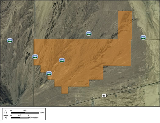
Land within the SEZ is undeveloped scrubland characteristic of a semiarid basin. Vegetation is predominantly creosotebush and other low shrubs. The southwest portion of the SEZ is more densely vegetated with various trees and shrubs in addition to cacti. The intermittent Bouse Wash runs through the eastern portion of the SEZ. Annual rainfall averages 4 to 8 in. (10-20 cm).
The SEZ is undeveloped and rural, with few permanent residents in the area. Several unpaved roads cross the SEZ, and a corral and well are located on the western edge. Part of the SEZ is authorized by the BLM for grazing.
The surrounding area includes agricultural lands and associated structures, livestock corrals, and fences. U.S. 60, I-10, and several unpaved roads are located in the vicinity of the SEZ. Residential and other structures are located along U.S. 60.

The nearest major road access is via U.S. 60, which runs along the southeast border of the Brenda SEZ. For the Brenda SEZ, the nearest existing transmission line is a 500-kV east-west line located about 12 mi (19 km) south of the SEZ, and there is a designated transmission corridor adjacent to the southern SEZ boundary.
In the 2012 Solar PEIS, the BLM committed to establishing a monitoring and adaptive management strategy for each solar energy zone (SEZ). Through these strategies, the BLM will take an active role in the collection of baseline data for the SEZs.
The BLM has not yet begun the monitoring and adaptive management strategy for the Brenda SEZ. However, the BLM has conducted a pilot monitoring and adaptive management strategy for the Riverside East SEZ. In May 2016, the BLM released the Riverside East Solar Energy Zone Long Term Monitoring Strategy Final Report. The monitoring strategy document (PDF, 16.6 MB) is now available.
In the 2012 Solar PEIS, the BLM committed to preparing solar regional mitigation strategies (SRMSs) for the solar energy zones (SEZs). These regional mitigation strategies were intended to simplify and improve the mitigation process for future solar projects in SEZs.
On March 2, 2016, the BLM released the Regional Mitigation Strategy for the Arizona SEZs – Final Report (PDF, 5.5 MB). The Brenda SEZ is included in the strategy. The strategy identifies mitigation priorities and options in advance of development, and takes into account the resource conditions of the land and regional trends informed by BLM's recent Rapid Ecoregional Assessments. The strategy was developed in collaboration with stakeholders to address key issues such as where and how mitigation may be achieved and the costs associated with doing so.
With IM-2019-018, the BLM established policy that compensatory mitigation could not be required as a condition for project approvals. However, with the issuance of IM 2021-038 on July 14, 2021, the BLM rescinded the previous IM-2019-018. The BLM expects to establish policies which are aligned with EO 13990, SO 3398, and the priorities of the Department. During this interim period offices should consider and implement compensatory mitigation on a case-by-case basis, in consultation with state office and national office program specialists and the Office of the Solicitor as needed.
The purpose of the Brenda Model is to assess potential impacts associated with groundwater withdrawals to support solar energy development in the vicinity of the Brenda SEZ.
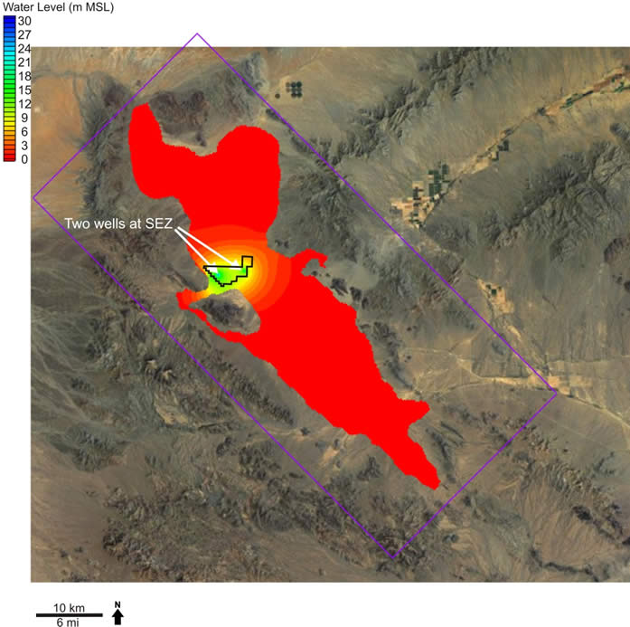
The Brenda SEZ model is a newly constructed model of the Ranegras Basin developed using public-domain geologic, hydrogeologic, and well pumping information and relying on the U.S. Geological Survey's MODFLOW 2000 code. Pre- and post-processing was performed using Groundwater Modeling System (GMS) version 9. In the first stage of the modeling, calibration of hydraulic conductivity and recharge was performed relying on pre-development steady-state water levels and transient water levels. Next, transient modeling was performed relying on historical agricultural pumping information in the basin. Finally, current pumping continued for 20 years into the future and included SEZ pumping to evaluate the effect of SEZ water requirements on groundwater drawdown.
Argonne National Laboratory's Division of Environmental Science staff constructed the Brenda groundwater model, which received independent peer-review and review by BLM hydrology staff.
The Brenda Model report has further information regarding its development and results.
The Brenda Model files are contained in several .zip files. Please see the “ReadMe.txt” file for a description of the model files. Please Note: These files are large and may involve long download times.
Note: Modeling was performed using GMS version 9.0 (64-bit) with a build date of March 25, 2013. The files are packaged in several .zip files. When unzipped, they may be useable by older or newer versions of GMS or by other commercial graphical user interfaces; however, functionality cannot be guaranteed.
Alterations to the Brenda Model could be made with the incorporation of new data regarding the hydrogeological framework and aquifer parameter values. As projects are planned, constructed, and begin operations, additional groundwater pumping scenarios can be analyzed and new data on head observations in monitoring wells can be used to refine the model.
For questions regarding the Brenda Model, please contact John Quinn.