Bureau of Land Management
Solar Energy Permitting and Program Resources
The Approved Record of Decision for Resource Management Plan Amendments for Utility-Scale Solar Energy Development was issued on December 20th, 2024 — details are available on the BLM's Utility-Scale Solar Energy Development PEIS/RMPA webpage. Relevant information on the 2024 Western Solar Plan and the BLM's Renewable Energy Rule issued in July 2024, is in the process of being updated on this website.
| California Variance Areas | Riverside East SEZ |
 |
 |
The Riverside East Solar Energy Zone (SEZ) is a designated leasing area (DLA) located in California on BLM-administered land within the Palm Springs South Coast Field Office.
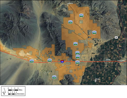
The Riverside East SEZ is the largest of the SEZs. In the 2010 Draft Solar PEIS, the proposed total area of the SEZ was 202,896 acres (821 km2). In the 2011 Supplement to the Draft, 43,439 acres (176 km2) in the northwest portion of the SEZ were eliminated to reduce impacts on Joshua Tree National Park. In addition, 11,547 acres (46.7 km2) within the SEZ boundaries were identified as non-development areas. The remaining developable area within the SEZ is 147,910 acres (598.6 km2). No additional changes to the SEZ developable area were made in the 2012 Final Solar PEIS.
The Riverside East SEZ is located in Riverside County in southeastern California, within Chuckwalla Valley, the southern portion of Palen Valley, and the California Desert Conservation Area (CDCA). The eastern boundary of the site is about 6 mi (10 km) west of the Arizona border. The revised western boundary is approximately 0.7 mi (1 km) from Joshua Tree National Park. In 2008, the county population was 84,443. The closest large cities are Moreno Valley, San Bernardino, and Riverside (all located slightly more than 100 mi [161 km] west of the SEZ on I-10).
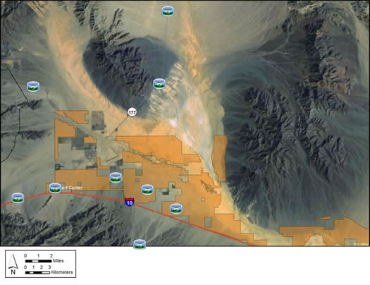
Flat basins form broad expanses of barren plains in the Riverside East SEZ. Much of the SEZ consists of flats with widely spaced creosote bushes and other low shrubs, but there are also dry lake beds, sandy areas, and dry washes with ironwood and other trees. Some areas are devoid or nearly devoid of vegetation.
In addition to I-10, State Route 177, and Midland Road, several gravel and dirt roads cross the SEZ. Transmission lines also cross the SEZ. An abandoned railroad runs through the eastern portion. The Midland Long Term Visitor Area is also located on the east side of the SEZ.
While the lands to the north and west of the SEZ are generally undeveloped mountains, the lands to the southeast are agricultural, and there is development along I-10 just south of the SEZ, though areas south of the SEZ beyond I-10 are generally undeveloped. The small town of Desert Center is located at the far southwestern edge of the SEZ, along Interstate 10 (I-10). There are ranches, homes, and associated structures located on private lands near the SEZ, as well as local roads and airstrips. Scattered tanks and other structures associated with ranching and farming are visible from the SEZ, as well as the abandoned Eagle Mountain Mine and Ironwood State Prison.

I-10 runs east-west along the southern boundary of the SEZ, State Route 177 runs north-south through the western section, and Midland Road crosses the northeastern portion of the SEZ. U.S. 95 runs north-south about 3 mi (5 km) from the eastern boundary of the SEZ.
An existing 500‑kV transmission line runs east-west along I-10 and parallel to the southern SEZ boundary. In addition, a 230‑kV line passes through the far western section of the SEZ, a 69‑kV line passes through the eastern portion of the SEZ, along with other transmission lines.
In the 2012 Solar PEIS, the BLM committed to establishing a long term monitoring and adaptive management strategy for each solar energy zone (SEZ). Through these strategies, the BLM will take an active role in the collection of baseline data for the SEZs.
The BLM, with input from stakeholders, conducted a pilot monitoring and adaptive management strategy project for the Riverside East SEZ. In May 2016, the BLM released the Riverside East Solar Energy Zone Long Term Monitoring Strategy Final Report. The monitoring strategy document (PDF, 16.6 MB) is now available.
The Riverside East SEZ was chosen for the monitoring pilot study because utility-scale solar development is already occurring in the SEZ. Four projects within or partially within the SEZ have already been authorized, and there are several additional pending applications within the SEZ. The purpose of the monitoring pilot at the Riverside East SEZ is twofold:
In order to produce the monitoring strategy, the BLM conducted the following activities:
Public outreach and stakeholder involvement was also a priority. The BLM held a public kick off meeting in December 2013 where a draft list of monitoring objectives for the SEZ was presented, and input on the draft monitoring objectives was obtained from stakeholders. The initial set of monitoring objectives was revised to accommodate stakeholder input. A webinar was held in May 2014, in which a prioritized list of monitoring objectives, indicators for achieving monitoring objectives, and a monitoring strategy outline were presented to stakeholders, at which time webinar participants were asked to provide input on the initial prioritization of monitoring objectives. The BLM hosted a public webinar on October 2015 to present the draft long term monitoring strategy and provide a forum for discussions, questions, comments, and clarifications. Comments on the draft monitoring strategy were reviewed and incorporated into the Final Report as applicable.
Current activities focus on the implementation of the long term monitoring strategy at the Riverside East SEZ. These activities include developing a detailed sampling plan describing current monitoring data collected at the SEZ and additional sampling that would be needed to achieve the higher priority monitoring objectives identified in the long-term monitoring plan. Monitoring data will be made publicly available through periodic reports describing sampling sites, methods, and the status and trend of resources as suggested by the data analysis.
For additional information, contact Jeremiah Kraruzas ([email protected]) or Mark Massar ([email protected]).
In the 2012 Solar PEIS, the Bureau of Land Management (BLM) committed to establishing a solar regional mitigation strategy for each solar energy zone (SEZ). These regional mitigation strategies are expected to simplify and improve the mitigation process for future solar projects in SEZs.
The BLM has completed regional mitigation strategies for the Arizona SEZs, the Colorado SEZs, and the Dry Lake and Dry Lake Valley North SEZs in Nevada. The Desert Renewable Energy Conservation Plan (DRECP) Land Use Plan Amendment (finalized in September 2016) provides the mitigation strategy for renewable energy development throughout the southern California desert as a whole, including the California SEZs (Imperial East, Riverside East, and West Chocolate Mountains SEZs). Details of the strategy identified by the DRECP Land Use Plan Amendment are provided in the Final BLM DRECP Land Use Plan and Environmental Impact Statement, Volume VI.
The purpose of the Riverside East Model is to assess potential impacts associated with groundwater withdrawals to support solar energy development in the vicinity of the Riverside East SEZ.
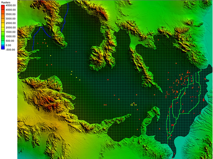
The Riverside East model considered three groundwater pumping scenarios (low, medium, and high) based on full build-out assumptions of the SEZ and was constructed using available hydrogeologic data and existing models for the basin. The U.S. Geological Survey’s MODFLOW 2000 code was used to construct a numerical (finite-difference) model, and pre- and post-processing was performed using Groundwater Modeling System (GMS) version 8.3. Calibration of hydraulic conductivity and recharge was performed, relying on pre-1942 steady-state water levels and transient water levels resulting from mining, agricultural and municipal pumping through 2010. A final simulation assessed 20 years of groundwater pumping within the Riverside East SEZ to evaluate its effect on groundwater drawdown relative to existing groundwater pumping for various uses in the basin.
Argonne National Laboratory's Division of Environmental Science staff constructed the Riverside East groundwater model, which received independent peer-review and review by BLM hydrology staff.
The Riverside East Model report has further information regarding its development and results.
The Riverside East Model files are contained in several .zip files. Please see the “ReadMe.txt” file for a description of the model files.
Note: Modeling was performed using GMS version 8.3.4.16592 (64-bit) with a build date of August 24, 2012. The files are packaged in several zip files. When unzipped, they may be useable by older or newer versions of GMS or by other commercial graphical user interfaces; however, functionality cannot be guaranteed.
Alterations to the Riverside East Model could be made with the incorporation of new data regarding the hydrogeological framework and aquifer parameter values. As projects are planned, constructed, and begin operations additional groundwater pumping scenarios can be analyzed and new data on head observations in monitoring wells can be used to refine the model.
For questions regarding the Riverside East Model, please contact John Quinn.