The Approved Record of Decision for Resource Management Plan Amendments for Utility-Scale Solar Energy Development was issued on December 20th, 2024 — details are available on the BLM's Utility-Scale Solar Energy Development PEIS/RMPA webpage. Relevant information on the 2024 Western Solar Plan and the BLM's Renewable Energy Rule issued in July 2024, is in the process of being updated on this website.
| New Mexico Variance Areas | Afton SEZ |
 |
 |
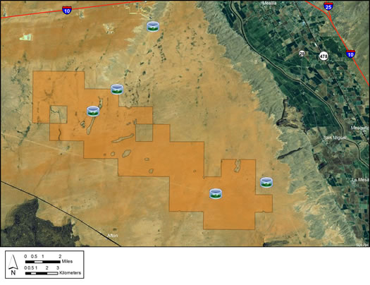
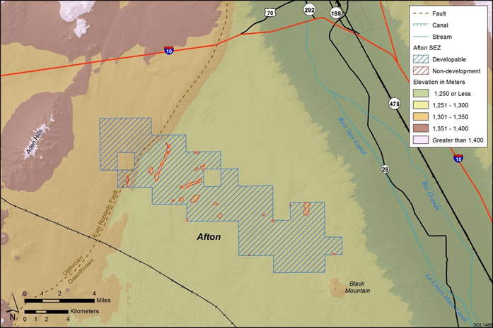
The Afton Solar Energy Zone (SEZ) is a designated leasing area (DLA) located in New Mexico in a semiarid basin with undeveloped scrubland. The SEZ is located on BLM-administered land within the Las Cruces District.
In the 2010 Draft Solar PEIS, the proposed Afton SEZ had a total area of 77,623 acres (314 km2). In the 2011 Supplement to the Draft, the SEZ was significantly reconfigured to eliminate 46,917 acres (190 km2) of land. Lands were eliminated at the north, northeast, southeast, and southwest boundaries, in order to focus potential solar development in the area along the existing Section 368 corridor, where development already exists. In addition, 742 acres (3 km2) of floodplain and intermittent and dry lake non-development areas within the remaining SEZ boundaries were identified. The remaining developable area within the SEZ is 29,964 acres (121.2 km2). No additional changes to the SEZ developable area were made in the 2012 Final Solar PEIS.
The Afton SEZ is located in Dona Ana County in southern New Mexico, 21 mi (34 km) north of the border with Mexico. The SEZ is located in the West Mesa of Mesilla Basin bordered on the north by Rough and Ready Hills and Robledo Mountain; on the west by Sleeping Lady Hills, Aden Hills, and West Potrillo Mountains; and on the east by Mesilla Valley. In 2008, the county population was 206,486. Las Cruces is the largest town within a 5-mi (8-km) radius of the SEZ.

The land within the SEZ is undeveloped scrubland characteristic of a semiarid basin. Vegetation within the SEZ is predominantly creosotebush, mesquite, and other low shrubs.
Dirt and gravel roads, existing transmission towers, pipeline, and cleared rights-of-way (ROWs) are located within the SEZ. A cheese factory, electric power plant, natural gas peaker plant, mining activity at Little Black Mountain, and other developments are visible at the SEZ boundaries. Part of the SEZ is authorized by the BLM for grazing.

The nearest major road access is via Interstate-10 (I-10), which runs east to west about 3 mi (5 km) to the north of the revised border of the Afton SEZ. A 345-kV transmission line passes through the SEZ.
In the 2012 Solar PEIS, the BLM committed to establishing a monitoring and adaptive management strategy for each solar energy zone (SEZ). Through these strategies, the BLM will take an active role in the collection of baseline data for the SEZs.
The BLM has not yet begun the monitoring and adaptive management strategy for the Afton SEZ. However, the BLM has conducted a pilot monitoring and adaptive management strategy for the Riverside East SEZ. In May 2016, the BLM released the Riverside East Solar Energy Zone Long Term Monitoring Strategy Final Report. The monitoring strategy document (PDF, 16.6 MB) is now available.
In the 2012 Solar PEIS, the BLM committed to preparing solar regional mitigation strategies (SRMSs) for the solar energy zones (SEZs). These regional mitigation strategies were intended to simplify and improve the mitigation process for future solar projects in SEZs.
The BLM began development of a solar regional mitigation strategy for the Afton SEZ in 2016. Information on the draft Afton Solar Regional Mitigation Strategy is available on the project website, linked below.
With IM-2019-018, the BLM established policy that compensatory mitigation could not be required as a condition for project approvals. However, with the issuance of IM 2021-038 on July 14, 2021, the BLM rescinded the previous IM-2019-018. The BLM expects to establish policies which are aligned with EO 13990, SO 3398, and the priorities of the Department. During this interim period offices should consider and implement compensatory mitigation on a case-by-case basis, in consultation with state office and national office program specialists and the Office of the Solicitor as needed.
Interested parties can learn more by visiting the Afton SRMS project website at:
https://blmsolar.anl.gov/solar-peis/sez/nm/regional-mitigation/
The purpose of the Afton model is to assess potential impacts associated with groundwater withdrawals to support solar energy development in the vicinity of the Afton SEZ. This SEZ is located southwest of Las Cruces, New Mexico.

The Afton SEZ model is an update of the one-dimensional modeling performed as part of the 2012 Solar Programmatic Environmental Impact Statement. The model is based on the Theis-Jacob method, and it relies on a thorough review of available hydrogeologic data and an assessment of the sensitivity of parameter values. Twenty years of high-, medium-, and low-demand groundwater pumping at the SEZ were modeled, producing estimates of the additional groundwater drawdown due to full build-out of the SEZ. The medium-demand case was selected for sensitivity analyses.
The Afton SEZ model report has further information regarding its development and results.
The Afton model file is a single Excel spreadsheet.
Note: Alterations to the Afton Model could be made with the incorporation of new data regarding the hydrogeological framework and aquifer parameter values.
For questions regarding the Afton model, please contact John Quinn.