Bureau of Land Management
Solar Energy Permitting and Program Resources
The Approved Record of Decision for Resource Management Plan Amendments for Utility-Scale Solar Energy Development was issued on December 20th, 2024 — details are available on the BLM's Utility-Scale Solar Energy Development PEIS/RMPA webpage. Relevant information on the 2024 Western Solar Plan and the BLM's Renewable Energy Rule issued in July 2024, is in the process of being updated on this website.
| Nevada Variance Areas | Amargosa Valley SEZ |
 |
 |
The Amargosa Valley Solar Energy Zone (SEZ) is a designated leasing area (DLA) located in Nevada in the Amargosa Desert in a semiarid basin on undeveloped scrubland. The SEZ is located on BLM-administered land within the Southern Nevada District.
In the 2010 Draft Solar PEIS, the proposed Amargosa Valley SEZ had a total area of 31,625 acres (128 km2). In the 2011 Supplement to the Draft, 21,888 acres (88.6 km2) south and west of the Amargosa River floodplain and the area northeast of U.S. 95 were eliminated. Excluding these areas will mitigate many potential impacts, including impacts on Death Valley National Park and desert tortoise. In addition, 1,258 acres (5.1 km2) of Amargosa River floodplain within the SEZ boundaries have been identified as non-development areas. The remaining developable area within the SEZ is 8,479 acres (34.3 km2). No additional changes to the SEZ developable areas were made in the 2012 Final Solar PEIS.
The Amargosa Valley SEZ is located in southern Nevada in Nye County near the California border. The SEZ is located in the Amargosa Desert, which lies in a valley between Funeral Mountains to the southwest and Yucca Mountain to the northeast. In 2008, the county population of Nye was 44,175, while adjacent Clark County to the southeast had a population of 1,879,093. The closest towns are Beatty, about 11 mi (18 km) north, and Amargosa Valley, about 12 mi (19 km) southeast.
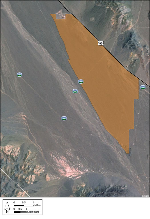
Land within the SEZ is undeveloped scrubland characteristic of a semiarid basin. Vegetation within the SEZ is predominantly creosotebush, white bursage, and other low shrubs. The Amargosa River, an ephemeral river, drains the valley and passes across the SEZ from northwest to southeast.
U.S. 95 runs along the northeast boundary of the revised SEZ. Dirt roads are present within the interior of the SEZ, and some areas have severe tracking from off-highway vehicle use.
The mountain slopes and peaks surrounding the SEZ are visually pristine. The lack of cultural disturbances, the general remoteness of the area, lack of humidity, and the exceptional air quality contribute to unusually dark night skies in the Amargosa Valley and nearby Death Valley National Park.

Access to the Amargosa Valley SEZ is via U.S. 95. A 138-kV transmission line runs along the northeast side of U.S. 95 and along the northeast border of the SEZ.
In the 2012 Solar PEIS, the BLM committed to establishing a monitoring and adaptive management strategy for each solar energy zone (SEZ). Through these strategies, the BLM will take an active role in the collection of baseline data for the SEZs.
The BLM has not yet begun the monitoring and adaptive management strategy for the Amargosa Valley SEZ. However, the BLM has conducted a pilot monitoring and adaptive management strategy for the Riverside East SEZ. In May 2016, the BLM released the Riverside East Solar Energy Zone Long Term Monitoring Strategy Final Report. The monitoring strategy document (PDF, 16.6 MB) is now available.
In the 2012 Solar PEIS, the BLM committed to preparing solar regional mitigation strategies (SRMSs) for the solar energy zones (SEZs). These regional mitigation strategies were intended to simplify and improve the mitigation process for future solar projects in SEZs.
SRMSs have been completed for two Nevada SEZs (Dry Lake and Dry Lake Valley North), but not for the Amargosa Valley, Gold Point, or Millers SEZs in NV. With IM-2019-018, the BLM established policy that compensatory mitigation could not be required as a condition for project approvals. However, with the issuance of IM 2021-038 on July 14, 2021, the BLM rescinded the previous IM-2019-018. The BLM expects to establish policies which are aligned with EO 13990, SO 3398, and the priorities of the Department. During this interim period offices should consider and implement compensatory mitigation on a case-by-case basis, in consultation with state office and national office program specialists and the Office of the Solicitor as needed.
The 2012 Solar PEIS evaluated potential impacts to groundwater resources at the Amargosa Valley SEZ by comparing groundwater pumping scenarios relative to the water balance for the basin, and through an analytical one-dimensional (1D) groundwater model. Results from the 1D groundwater model are shown in the figure below, which depicts potential groundwater drawdown resulting from 20 years of withdrawals considering three different water demand scenarios.
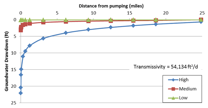
Groundwater drawdown is a concern in the region of the Amargosa Valley SEZ because of connectivity between the groundwater system and the seeps and streams associated with Ash Meadows National Wildlife Refuge and Devils Hole that support threatened and endangered species, most notably the Devils Hole pupfish. The complexity of the groundwater system in the region of the SEZ and the importance of groundwater resources suggest that the analysis of groundwater impacts performed for the 2012 Solar PEIS should be considered preliminary, and further groundwater modeling studies should be performed to assess potential impacts from groundwater withdrawals.
The Amargosa Valley SEZ is located within the Amargosa Desert groundwater basin, which is a part of the regional-scale Death Valley Regional Groundwater Flow System (DVRFS) that encompasses several surrounding valleys in southern Nevada and portions of California. The U.S. Geological Survey (USGS) has developed a numerical three-dimensional (3D) transient groundwater model for the DVRFS. The archive for the DVRFS model, including the model files and geospatial datasets, are also provided through the USGS model Web page. The geospatial datasets and “DVRFS” can be searched to find relevant geospatial datasets.
The DVRFS groundwater model was developed using the 2000 version of the U.S. Geological Survey's Modular Three-Dimensional Finite-Difference Groundwater Flow Model (MODFLOW-2000). The MODFLOW-2000 Web page includes manuals and information on source code and add-ons.
The USGS also developed a guide specific to the use the DVRFS groundwater model, which provides instructions for modifying the model files in order to assess groundwater pumping scenarios.
The Southern Amargosa Embedded Model (SAMM) is currently being developed by the USGS as a follow-on study to the development of the DVRFS groundwater model. The SAMM groundwater model is specifically being developed to provide high-resolution groundwater simulations of the Amargosa Desert groundwater basin to address questions regarding groundwater-supported ecosystems of Ash Meadows and Devils Hole, solar energy development, mesquite-woodland habitats, and water right issues.
For questions regarding groundwater resources at the Amargosa Valley SEZ, please contact John Quinn.