Bureau of Land Management
Solar Energy Permitting and Program Resources
The Approved Record of Decision for Resource Management Plan Amendments for Utility-Scale Solar Energy Development was issued on December 20th, 2024 — details are available on the BLM's Utility-Scale Solar Energy Development PEIS/RMPA webpage. Relevant information on the 2024 Western Solar Plan and the BLM's Renewable Energy Rule issued in July 2024, is in the process of being updated on this website.
| Colorado Variance Areas | Antonito Southeast SEZ |
 |
 |
The Antonito Southeast Solar Energy Zone (SEZ) is a designated leasing area (DLA) located in Colorado in a semiarid basin with undeveloped scrubland currently used for BLM-authorized grazing. The SEZ is located on BLM-administered land within the La Jara Field Office.
The Antonito Southeast SEZ has a total area of 9,729 acres (39.4 km2). In the 2011 Supplement to the Draft Solar PEIS, 17 acres (0.07 km2) of wetland and lake areas were identified as non-development areas, leaving the SEZ with a potentially developable area of 9,712 acres (39.3 km2). No additional changes to the SEZ developable area were made in the 2012 Final Solar PEIS.
The Antonito Southeast SEZ is located in southeastern Conejos County on the New Mexico border in the south-central part of the San Luis Valley. The San Luis Valley is bounded by the San Juan Mountains to the west and the Sangre de Cristo Range to the east. The largest nearby town of Alamosa is located about 34 mi (55 km) to the north. In 2008, the county population was 8,232, while the surrounding six-county region in Colorado and New Mexico had a population of 116,511.
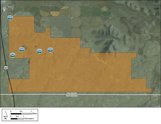
The Antonito Southeast SEZ is located in a flat to gently rolling, largely treeless plain. Land within the SEZ is undeveloped scrubland characteristic of a high-elevation, semiarid basin. Vegetation is primarily low shrubs such as rabbitbrush and grasses. The SEZ is dissected by dry washes. Alta Lake is an ephemeral water body located in the north-central portion of the SEZ that was identified as a non-development area in the 2011 Supplement to the Draft Solar PEIS.
Several unpaved roads cross the SEZ, and there are remnants of a historic railroad and an irrigation reservoir and canal system. Part of the SEZ is authorized by the BLM for grazing.
There is little industrial development in the vicinity of the SEZ, other than a perlite processing plant approximately 0.75 mi (1.2 km) north-northwest of its northwest corner. The land areas to the west, north and east of the SEZ are comprised of a mix of BLM-administered and private lands; the area immediately to the north is private land used for agriculture, with irrigation water supplied mainly from surface water sources. The area to the south of the SEZ is BLM-administered land in New Mexico.

The SEZ is adjacent to U.S. 285, and the nearest existing transmission line is a 69-kV line that is located about 3 mi (5 km) north of the SEZ.
In the 2012 Solar PEIS, the BLM committed to establishing a monitoring and adaptive management strategy for each solar energy zone (SEZ). Through these strategies, the BLM will take an active role in the collection of baseline data for the SEZs.
The BLM has not yet begun the monitoring and adaptive management strategy for the Antonito Southeast SEZ. However, the BLM has conducted a pilot monitoring and adaptive management strategy for the Riverside East SEZ. In May 2016, the BLM released the Riverside East Solar Energy Zone Long Term Monitoring Strategy Final Report. The monitoring strategy document (PDF, 16.6 MB) is now available.
In the 2012 Solar PEIS, the BLM committed to preparing solar regional mitigation strategies (SRMSs) for the solar energy zones (SEZs). These regional mitigation strategies were intended to simplify and improve the mitigation process for future solar projects in SEZs.
In January 2017, the BLM released the Regional Mitigation Strategy for the Colorado Solar Energy Zones – Final Report (PDF, 26.1 MB). This document addresses regional mitigation for the Antonito Southeast SEZ and two other SEZs in Colorado's San Luis Valley. Additional supporting studies were released with the Regional Mitigation Strategy; all the documents are available through the BLM's Renewable Energy Mitigation webpage.
With IM-2019-018, the BLM established policy that compensatory mitigation could not be required as a condition for project approvals. However, with the issuance of IM 2021-038 on July 14, 2021, the BLM rescinded the previous IM-2019-018. The BLM expects to establish policies which are aligned with EO 13990, SO 3398, and the priorities of the Department. During this interim period offices should consider and implement compensatory mitigation on a case-by-case basis, in consultation with state office and national office program specialists and the Office of the Solicitor as needed.