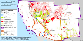
Variance Areas
Variance areas are BLM-administered lands in Arizona, Colorado, Nevada, New Mexico, Utah, and parts of California not covered by the DRECP Record of Decision (ROD) that are:
- outside of solar energy zones (SEZs), and
- not otherwise excluded under the 2012 Western Solar Plan
The requirements of the 2012 Western Solar Plan are applicable to all applications filed in variance areas after October 28, 2011. The BLM will consider right-of-way (ROW) applications for utility-scale solar energy development in variance areas on a case‑by‑case basis based on environmental considerations; coordination with appropriate Federal, State, and local agencies and tribes; and public outreach. This evaluation is referred to as the variance process.
Maps of Variance Areas in the six-state 2012 Solar PEIS study area are available on the Maps page. Changes in Land Use Plans over time may result in changes to Exclusion and Variance areas.
The BLM will process renewable energy applications for solar energy ROW grants in variance areas according to the regulations at 43 CFR 2800 and subparts as outlined under Non-Competitive Process.
Variance Process
For the six states covered under the 2012 Western Solar Plan, responsible utility-scale solar energy development is allowed in variance areas outside of SEZs in accordance with the established variance process. The right-of-way (ROW) regulations at 43 CFR 2804.35 state that lands outside of designated leasing areas [DLAs] but specifically identified as appropriate for solar energy development will be processed under 43 CFR 2804 which provides for the issuance of a solar energy ROW grant (43 CFR 2804). Lands identified as variance areas qualify as “identified as appropriate for solar energy development”.
- The 2012 Western Solar Plan also established programmatic design features that are required for utility-scale solar energy development on BLM-administered lands in the six-states covered. These programmatic design features avoid, minimize, and mitigate adverse impacts on resources of concern
- 2012 Solar PEIS programmatic design features may be considered in grant stipulations for solar energy development on BLM-administered lands outside of the six-state 2012 Solar PEIS area.
The components of the variance process are explained below:
Preliminary Meetings and Application Submittal
Preliminary meetings are required for all solar energy applications outside of DLAs in the six-state area covered under the 2012 Western Solar Plan, except for areas in California covered by the DRECP ROD.
The application submittal process is also required for applications in these areas.
Factors to be Considered by BLM
Information summarized from 2012 Western Solar Plan, Appendix B., Section B.5.3.
The BLM considers a variety of factors when evaluating ROW applications in variance areas. The focus of the variance process is on collecting the right data and evaluating it with the right parties to assess the appropriateness of a given proposal, rather than on a prescriptive set of measures that would be established at the programmatic level.
The BLM considers the following factors, as appropriate, when evaluating ROW applications in variance areas:
- The availability of lands in an SEZ that could meet the applicant's needs, including access to transmission.
- Documentation that the proposed project will be in conformance with decisions in current land use plan(s) (e.g., Visual Resource Management class designations and seasonal restrictions) or, if necessary, represents an acceptable proposal for a land use plan amendment.
- Documentation that the proposed project will be consistent with priority conservation, restoration, and/or adaptation objectives in the best available landscape-scale information (e.g., landscape conservation cooperatives, rapid ecological assessments, and State and regional-level crucial habitat assessment tools [CHATs]).
- Documentation that the proposed project can meet applicable programmatic design features adopted in the 2012 Western Solar Plan (Appendix A, Section A.4.1).
- Documentation that the applicant has coordinated with State and local (county and/or municipal) governments, including consideration of consistency with officially adopted plans and policies (e.g., comprehensive land use plans, open space plans, and conservation plans) and permit requirements (e.g., special use permits).
- Documentation of the financial and technical capability of the applicant, including, but not limited to, the following:
- International or domestic experience with solar energy projects on either Federal or non-Federal lands; and
- Sufficient capitalization to carry out development, monitoring, and decommissioning, including the preliminary study phase of the project and the environmental review and clearance process.
- Documentation that the proposed project is in an area with low or comparatively low resource conflicts and where conflicts can be resolved (as demonstrated through many of the factors that follow).
- Documentation that the proposed project will optimize the use of existing roads.
- Documentation that the proposed project will optimize the capacity of existing and new transmission infrastructure, and avoid duplication in the use of or need for existing and new transmission and transmission interconnection facilities.
- Documentation that the proposed project will make efficient use of the land considering the solar resource, the technology to be used, and the proposed project layout.
- If applicable, documentation that the proposed project will be located in an area identified as suitable for solar energy development in an applicable BLM land use plan and/or by another related process such as the California Desert Renewable Energy Conservation Plan (DRECP) (e.g., Development Focus Areas) or Arizona Restoration Design Energy Project (RDEP) (e.g., Renewable Energy Development Areas).
- If applicable, special circumstances associated with an application such as an expansion or repowering of an existing project or unique interagency partnership.
- If applicable, opportunities to combine Federal and non-Federal lands for optimum siting (e.g., combining BLM-administered land with adjacent previously disturbed private lands).
- If applicable, documentation that the proposed project will be located in, or adjacent to, previously contaminated or disturbed lands such as brownfields identified by the U.S. Environmental Protection Agency's (EPA's) RE-Powering America's Land Initiative or State, local, and/or tribal authorities; mechanically altered lands such as mine-scarred lands and fallowed agricultural lands; idle or underutilized industrial areas; lands adjacent to urbanized areas and/or load centers; or areas repeatedly burned and invaded by fire-promoting non-native grasses where the probability of restoration is determined to be limited. Preference will be given to proposed projects that are located in, or adjacent to, previously contaminated or disturbed lands under the variance process, assuming all other factors are adequately considered.
- Documentation that the proposed project will minimize adverse impacts on access and recreational opportunities on public lands (including hunting, fishing, and other fish- and wildlife-related activities).
- Documentation that the proposed project will minimize adverse impacts on important fish and wildlife habitats and migration/movement corridors (e.g., utilizing the Western Wildlife CHAT, administered by the Western Association of Fish and Wildlife Agencies and coordinating with State fish and wildlife agencies).
- Documentation that the proposed project will minimize impacts on lands with wilderness characteristics and the values associated with these lands (e.g., scenic values, recreation, and wildlife habitat).
- Documentation that the proposed project will be designed, constructed, and operated to optimize the specific generation technology's efficiencies with respect to water impacts.
- Documentation that any groundwater withdrawal associated with a proposed project will not cause or contribute to withdrawals over the perennial yield of the basin, or cause an adverse effect on Endangered Species Act (ESA)-listed or other special status species or their habitats over the long term. However, where groundwater extraction may affect groundwater-dependent ecosystems, and especially within groundwater basins that have been over appropriated by State water resource agencies, an application may be acceptable if commitments are made to provide mitigation measures that will provide a net benefit to that specific groundwater resource over the duration of the project.
- Determination of impacts on groundwater will likely require applicants to undertake hydrological studies using available data and accepted models.
- Documentation that the proposed project will not adversely affect lands donated or acquired for conservation purposes, or mitigation lands identified in previously approved projects such as translocation areas for desert tortoise.
- Documentation that significant cumulative impacts on resources of concern should not occur as a result of the proposed project (i.e., exceedance of an established threshold such as air quality standards).
- If applicable, documentation on evaluation of desert tortoise impacts based on the variance protocol for desert tortoise.
- If applicable, documentation on evaluation of greater sage-grouse impacts based on the variance protocol for greater sage-grouse.
- If applicable, documentation on evaluation of impacts to National Park Service (NPS) units and other special status areas under NPS administration as defined in the variance protocol for resources and values of units of the NPS.
Public Outreach
The BLM requires public outreach as part of the variance process.
To sufficiently gather information on potential issues and barriers and/or opportunities related to a right-of-way (ROW) application in a variance area, the BLM requires that a minimum of one public meeting be held as part of the variance process to allow for participation by all interested parties. The public meeting must be located in close proximity to the community most affected by the proposed project and shall be adequately noticed.
This variance process requirement for a public meeting will occur before the National Environmental Policy Act (NEPA) process is initiated. However, comments received may be used to inform the NEPA process for projects that the BLM decides to continue to process.
The BLM also makes information regarding ROW applications in variance areas available to the public online.
Coordination Activities
As part of the variance process, the BLM coordinates with appropriate Federal, State, and local government agencies and tribes. The review of right-of-way (ROW) applications in coordination with these other entities helps the BLM determine the potential for impacts on important resources; explore ways to avoid, minimize, and/or mitigate such impacts; and ensure consistency with relevant plans, policies, and initiatives. Coordination activities include the following:
- Consultation with tribes. Government-to-government consultation with tribal staff provides opportunities for tribes to identify traditional cultural properties and sacred sites with applications in variance areas. Tribes are invited to attend pre-application meetings with the applicant and the BLM. On the basis of information and discussions arising from the pre-application meetings, the BLM determines whether there is a need for new ethnographic research to provide sufficient information to adequately consider the effects of solar energy development on issues and resources of concern to tribes. BLM field office cultural staff, including specialists assigned to Renewable Energy Coordination Offices where present, in consultation with their Deputy Preservation Officer, recommend to responsible BLM line officers whether to collect additional ethnographic data for a given solar application. Should new ethnographic research, studies, or interviews be recommended, the BLM cultural staff, in consultation with tribal officials, will provide guidance to BLM line officers about the appropriate scope of that work, provisions for safeguarding data confidentiality, and programs of mitigation.
- Coordination with the State Historic Preservation Office (SHPO). The BLM consults with the SHPO to determine the steps required to identify historic properties in the area of effect for the ROW application. Additional inventories may include Class II or Class III surveys in areas of direct and indirect effect, depending on the potential for impacts. On the basis of the results of the inventory, determinations of eligibility of sites to the National Register of Historic Places (NRHP), determinations of effect, and programs of mitigation would be approved by the BLM and carried out by the applicant prior to ground disturbance.
- Coordination with State fish and wildlife agencies.
- For applications in the Desert Renewable Energy Conservation Plan (DRECP) planning area, the BLM will coordinate with California Renewable Energy Action Team (REAT) agencies (BLM, U.S. Fish and Wildlife Service [USFWS], California Department of Fish and Game [CDFG], and California Energy Commission [CEC]) to ensure consistency with any DRECP reserve and development area designs. The REAT agencies will evaluate applications in areas proposed for development, focus areas, and areas proposed for reserves on a case-by-case basis. The REAT agencies will consider the best available information, including data generated as part of the DRECP planning effort. The BLM may choose to defer or modify projects on a case-by-case basis if it determines that approval of the proposed project would harm resource values so as to limit the choice of reasonable alternative actions in the DRECP.
- Coordination with the National Park Service (NPS) to assess the potential for impacts on the resources and values of units of the NPS and other special status areas under NPS administration (e.g., National Scenic or Historic Trails).
- Coordination with the NPS, U.S. Forest Service (USFS), and/or BLM National Trails System Office charged with trail-wide administration or management for National Scenic or Historic Trails to review inventory adequacy or needs, and to assess potential adverse impacts on trails. Coordination is also required with the study agency for trails recommended as suitable in congressionally authorized Trail Feasibility Studies or trails undergoing such study. Coordination is also required with nonprofit National trail organizations for trails subject to exclusion provisions. Other related program coordination requirements must also be met, such as those for cultural resources, recreation and visitor services, visual resources, or National Conservation Lands.
- Coordination with the USFWS on any application that could result in impacts on Endangered Species Act (ESA)-listed species and their habitat (including, but not limited to, desert tortoise and greater sage-grouse), bald and golden eagles, and migratory birds.
- Coordination with State and local (county and/or municipal) governments to determine compatibility with officially adopted plans and policies (e.g., comprehensive land use plans, open space plans, conservation plans) and permit requirements (e.g., special use permits).
- Consultation with the U.S. Department of Defense (DoD). The BLM will consult the DoD to minimize and/or eliminate impacts on military operations and encourage compatible development. This consultation will include both general discussions for early planning and detailed assessments of specific proposals at the local level. The BLM will accept formal DoD submissions once they have been vetted through both the Military Departments and the DoD Siting Clearinghouse.
- Coordination with the U.S. Army Corps of Engineers (USACE).
- Coordination with the U.S. Environmental Protection Agency (EPA).
- Coordination with State and regional transmission planning efforts (e.g., Western Governors' Association [WGA], Nevada Renewable Energy Transmission Access Advisory Committee, New Mexico Renewable Energy Transmission Authority), transmission coordination authorities (e.g., Western Electricity Coordinating Council [WECC]), State energy offices, and transmission system operators to identify any transmission issues associated with the proposed project (e.g., capacity and land use considerations).
- Coordination with the railroad industry to determine the potential for impacts on railroad ROWs and railroad operations.
- Coordination with any potentially affected grazing permittee/lessee to discuss how the proposed project may affect grazing operations and address possible alternatives, as well as mitigation and compensation strategies.
- Coordination with existing ROW holders to determine potential impacts on existing BLM authorizations.
- Coordination with the owner of any Federal mining claims and/or mineral leases located within the boundaries of the proposed project to determine the potential for impacts on mining claims and/or mineral leases and discuss ways to avoid, minimize, or mitigate such impacts.
Variance Determination
The BLM has determined that, in appropriate circumstances, it can rely on the broad discretion it has under the Federal Land Policy and Management Act (FLPMA) of 1976 to deny right-of-way (ROW) applications without completing the National Environmental Policy Act (NEPA) of 1969 process. Such decisions must be made with regard for the public interest and be supported by reasoned analysis and an adequate administrative record. Decisions to deny pending applications must be assessed on a case-by-case basis. Denial of an application constitutes a “final agency action” and is therefore subject to administrative appeals to the Interior Board of Land Appeals (IBLA).
On the basis of a thorough evaluation of the information provided by an applicant and the input of Federal, State, and local government agencies, tribes, and the public, the BLM determines whether it is appropriate to continue to process, or to deny, a ROW application submitted through the variance process. Variance evaluations are conducted and documented at the BLM State and field office levels. To ensure a consistent application of the variance process, all ROW applications in variance areas that are determined to be appropriate for continued processing are submitted by the BLM State Director to the BLM Washington Office for the Director's concurrence.
ROW applications in variance areas that the BLM determines to be appropriate for continued processing are generally processed, at the applicant's expense, in compliance with NEPA and all other applicable laws, regulations, and policies. Proposed projects in variance areas require consideration of alternatives and usually result in environmental impact statement (EIS)-level NEPA documentation. Compliance with applicable laws, regulations, and policies could result in substantial changes to a project proposal or application denial.