Bureau of Land Management
Solar Energy Permitting and Program Resources
The Approved Record of Decision for Resource Management Plan Amendments for Utility-Scale Solar Energy Development was issued on December 20th, 2024 — details are available on the BLM's Utility-Scale Solar Energy Development PEIS/RMPA webpage. Relevant information on the 2024 Western Solar Plan and the BLM's Renewable Energy Rule issued in July 2024, is in the process of being updated on this website.
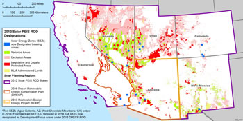
Solar Energy Zones (SEZs) are defined as areas well suited for utility-scale production of solar energy, where the BLM will prioritize solar energy and associated transmission infrastructure development. The SEZs are identified as Designated Leasing Areas (DLAs) in BLM's leasing regulations (43 CFR 2800). Planning requirements for solar development within SEZs include National Environmental Policy Act (NEPA) analysis:
The 2012 Western Solar Plan identified 285,000 acres of BLM-administered lands in 17 SEZs in Arizona, California, Colorado, Nevada, New Mexico, and Utah. In 2013 two additional SEZs were identified through different planning efforts: the 2,560 acre Agua Caliente SEZ in Arizona and the 10,759 acre West Chocolate Mountains SEZ in California.
There are 3 SEZs in Arizona, 3 SEZs in California, 3 SEZs in Colorado, 5 SEZs in Nevada, 1 SEZ in New Mexico, and 3 SEZs in Utah. In 2018 the area of the 3,882 acre Fourmile East SEZ in Colorado was de-allocated as an SEZ due to identification of significant cultural resources. The requirements of the 2012 Western Solar Plan are applicable to all applications filed within SEZs after June 30, 2009.
Detailed state-level maps are available, as well as SEZ-level maps located on SEZ-specific web pages.